

Habitats of the Metedeconk subwatershed are numerous and diverse. They are comprised of forests/woodlands, freshwater, forested wetlands, salt marshes, and tidal wetlands. The Metedeconk River itself is of a floodplain type, due to its connectivity to the Atlantic Ocean. In lieu of this connection to the ocean and the Barnegat Bay, the river experiences tidal fluctuations; the head of tide is just east of the Garden State Parkway. The brackish estuarine water of the Metedeconk River begins around Route 70 in Brick Township, and is freshwater upstream from there along both branches.
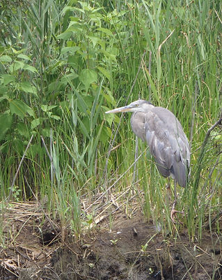
Due to the richness and productivity of the waters and surrounding habitats, numerous species of wildlife are attracted to the areas. There are 156 species of special emphasis (52 species of fish and 79 species of birds), found in and around the watershed. Due to the watershed’s location along migratory flyways, you can expect to find various species of endangered and threatened species of waterfowl, shorebirds, birds of prey, and other species of birds. Endangered species like the Peregrine falcon, the Roseate tern, the Northern harrier, and the Black skimmer, threatened species like the Piping plover, the great blue and little blue Herons, the Osprey, and the Barred owl, all can be found throughout the areas. Other species of animals like the Eastern tiger salamander and the Northern pine snake can also be found in the watershed. Species of mammals like the Whitetail deer, river otters, beavers, and red foxes can all be seen. Many species of finfish can be found and are regularly sought out in the watershed’s waters. Species like Bluefish, Striped bass, Menhaden, Spot, Weakfish, white and yellow Pearch , summer and winter Flounder all inhabit the waters, depending on the season. Crabbing for the Blue claw crab can also be extremely productive and is also a popular activity.
History of forge pond
In March of 1808, Thomas Jefferson, President of the United States, signed the third Embargo Act cutting off trade with England and France. In that same year, John Lippencott, of Mount Holly, Burlington County purchased one hundred and five acres of land from the New Jersey Proprietors.
The land Lippencott purchased was at the southern end of Monmouth County in Howell Township and north of the Dover Township line on the Metetecunk (Metedeconk) River near Indian Stage, the site of many Lenape ceremonies. The area was later to become Brick Township; the area was ideal for an iron forge business. There was ample bog ore in the nearby marshes. The surrounding woodlands supplied the wood for charcoal needed to heat the forge and the river provided transportation and power. Two years after purchasing the land Lippencott sold the tract of land to Banajah Butcher and Barzillai Burr of Mount Holly, Burlington County. In 1810, Butcher and Burr received New Jersey State Legislative permission to construct a dam across the Metedeconk River creating a mill pond for the purpose of working the forge and grist mill which had recently been constructed. According to Thomas Gordon’s History and Gazetteer of New Jersey, in 1834 the mill pond was the largest in the state at about three miles long by one half mile wide. In 1847, the dam broke washing away the Forge along with several homes and business that grew up around the Forge.
The Forge produced mainly water pipes sold in New York City where there was a ready market. According to Early Forges and Furnaces in New Jersey the majority of early water mains in lower Manhattan came from Butcher’s Forge. Because of the lack of good roads, products from the forge were shipped on sailing ships via Gravelley Docks about a quarter mile east on the north shore of the Metedeconk river, at the opening to the north branch. The sailing ships traveled south down Barnegat Bayand through Cranberry inlet to the Atlantic Ocean. When nature closed Cranberry inlet around 1812, forge products were shipped by wagon over land to the Shrewsbury River. There it was loaded onto sailing vessels headed for New York City.
Today Bricktonians enjoy the picturesque view of Forge Pond from the park on the west side of Route 70. The trees, once harvested to produce charcoal for the forge, have grown back. The Laurel is growing again. Turtles, black snakes and other wildlife inhabits the pond. The winding Metedeconk River provides a link from its beginnings in western New Jersey through Lake Shanandoah to State Highway 70 and beyond.
The town was named for Joseph W. Brick, the proprietor of Bergen Iron Works and the areas most prominent citizen. Mr. Brick operated Bergen Iron Works, which was located in present day Lakewood Township, from 1833 until his death in 1847.
When Brick Township was created it included an area extending from the eastern boundary of Jackson Township to the west the Atlantic Ocean to the east from Monmouth County on the north to Dover Township on the south.
Midstream rental....just the facts
Midstream rental is located directly on the water at the Metedeconk river in ocean county close to the Jersey shore.
The Metedeconk River flows from its North Branch and its South Branch to their confluence at Forge Pond, where the river then widens up to just over 1 mile and flows southeast for 6 miles into the Barnegat Bay. It contains both fresh and salt-water portions. Like many area streets, waterways and towns, Metedeconk is the original word or phrase used by the pre-European peoples of the area, the Lenape.
At its most eastern face the river meets the Island Beach, a populated but narrow strip less than 1 mile separating the Metedeconk from a direct connection with the Atlantic Ocean. Here, the river joins the Barnegat Bay to the south and the narrow, man-made Point Pleasant Canal to the north. This canal provides a convenient connection to the Manasquan River, which would otherwise be completely separated from the Metedeconk by about 3 miles of land. The Manasquan River is directly connected to the Atlantic Ocean, as is Barnegat Bay.


